


















Your go-to guide for Toronto student life.

Best Nature Trails in Toronto to Explore
Published August 5, 2026 by Irem Erketir
Warmer weather means it’s time to swap indoor study sessions for outdoor fun! Whether you’re looking for a walk, a cycling adventure, stunning waterfront views, or a place to watch the sunset, Toronto offers a variety of trails suited to every activity level. Here are some of the city’s best nature trails to explore this summer, though most are just as rewarding in spring and fall.
Humber River Trail
Stretching through north, central, and south Etobicoke, the Humber River Trail is one of Toronto’s most diverse and picturesque trail systems. The trail takes visitors through lush green spaces and open parkland while offering sweeping views of the river. Along the route, you’ll find families enjoying picnics, sports fields filled with activity, and plenty of opportunities to stop and enjoy nature.
For cyclists, Bike Share Toronto stations are conveniently located near several access points, making it easy to rent a bike and explore longer sections of the trail. My typical route begins at Eglinton Avenue West and Scarlett Road before heading south toward Humber Bay Park East, which is the perfect spot to relax and take in the skyline views.
- Starting Point(s): Albion Road & Arcot Boulevard, Scarlett Road & Eglinton Avenue West, Old Mill Station, Palace Pier Park
- Difficulty: Moderate
- Distance: Approximately 20km from the Albion Road & Arcot Boulevard starting point to Sunnyside Park
- Walking Time: Est. 4-5 hours
- Cycling Time: Est. 1-2.5 hours
High Park Loop
Known as Toronto’s largest public park, High Park offers a nature escape in the heart of the city. The trail network goes through wooded areas, gardens, ponds, and open green spaces, making it an ideal destination for a casual summer stroll. Depending on the season, visitors can enjoy a variety of attractions, including the famous cherry blossoms in spring, outdoor performances, and community events.
Be sure to stop by the High Park Zoo, where visitors can see llamas, bison, peacocks, and other animals. The park’s many picnic areas and shaded pathways make it a perfect destination for families and friends looking to spend a relaxing afternoon outdoors.
- Starting Point: High Park Station
- Difficulty: Easy
- Distance: Approximately 5km
- Walking Time: Est. 1 hour

For more park strolls, check out our guide to Toronto parks.
Earl Bales Park Loop
Located in North York, Earl Bales Park is the perfect spot to step away from the city’s busy streets. During the summer, the park hosts outdoor concerts and community events, making it an excellent destination for both recreation and entertainment.
Although shorter than many of Toronto’s larger trail systems, Earl Bales Park provides a refreshing nature experience that is easily accessible and suitable for all fitness levels.
- Starting Point: Bathurst St & Sheppard Ave West
- Difficulty: Easy
- Distance: Approximately 2.9km
- Walking Time: Est. 0.5-1 hour
Martin Goodman Waterfront Trail
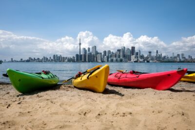
For those who love lakeside views, the Martin Goodman Waterfront Trail is a must-visit destination. Running along Toronto’s shoreline, the trail offers breathtaking views of Lake Ontario and the city skyline. Whether walking or cycling, you can enjoy a lively atmosphere filled with outdoor activity.
Bike Share Toronto stations are located throughout the route, making it easy to explore longer stretches of the trail. Along the way, you’ll pass through popular waterfront destinations including Sunnyside Beach, Coronation Park, Harbourfront, and Tommy Thompson Park. My typical route starts at Park Lawn Rd & Lakeshore Blvd West and typically ends at Harbourfront, where I reward myself with a sweet treat from either Ice Creamonolgy or Beavertails.
- Starting Point(s): Park Lawn Rd & Lakeshore Blvd West, Sunnyside Park, Coronation Park, Lakeshore Blvd East & Cherry St
- Difficulty: Easy
- Distance: Approximately 25km
- Walking Time: Est. 4-5 hours
- Cycling Time: Est. 0.5-1 hour
Riverdale East and West Park Loop
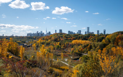
One of Toronto’s most iconic urban parks, the Riverdale East and West Park Loop combines gentle walking paths with some of the city’s best skyline views. The trail winds through expansive green spaces that are popular for picnics, sports, and outdoor recreation.
After completing the loop, visitors can head to the famous Riverdale Sunset Vista, where crowds gather on summer evenings to watch the sun set behind Toronto’s skyline. It’s a perfect spot to relax and capture memorable photos of the city.
- Starting Point: Castle Frank Station
- Difficulty: Easy
- Distance: Approximately 4km
- Walking Time: Est. 1-1.5 hour
Toronto Islands Trail
Just a short ferry ride from downtown, the Toronto Islands offer a peaceful escape from city life. The trail network connects Ward’s Island, Centre Island, and Hanlan’s Point, allowing visitors to explore beaches, gardens, lagoons, and quiet residential areas while enjoying stunning views of Toronto’s skyline.
Cycling is particularly popular on the islands due to the car-free environment and flat terrain. Visitors can rent bikes, spend time at the beach, or simply enjoy a leisurely walk surrounded by nature. My typical route starts at Ward’s Island, where I roam around the picturesque houses and drop by the beach, then continue towards Centre Island where I end my walk with a meal by the water.
- Starting Point(s): Ward’s Island, Centre Island, Hanlan’s Point
- Difficulty: Easy
- Distance: Approximately 6.5km
- Walking Time: Est. 1.5-2.5 hours
- Cycling Time: Est. 30 minutes
York-Kay Gardner-Beltline Trail
Hidden in the heart of midtown, the Beltline Trail is a scenic urban escape that follows the route of a former railway corridor. The trail goes through ravines, greenery, and residential neighbourhoods. Although the core Beltline trail runs from St Clair Station to Davisville Station, the trail actually extends to Caledonia Station through the Kay Gardner and York Beltline continuation.
Its relatively flat terrain makes it accessible for all ages and fitness levels. Whether you’re looking for a quick walk, a morning jog, or a relaxing afternoon surrounded by nature, the Beltline Trail is one of Toronto’s hidden gems worth exploring.
- Starting Point(s): 260 Bowie Avenue, Cedarvale Station, Davisville Station, St Clair Station
- Difficulty: Easy
- Distance: Approximately 13.5km
- Walking Time: Est. 2.5-3.5 hours
- Cycling Time: Est. 1 hour
Final Thoughts
Toronto’s trails offer something for everyone. Whether you’re staying active, chasing a good sunset, or just looking for an excuse to get outside, these are some of the best spots the city has to offer this summer.